

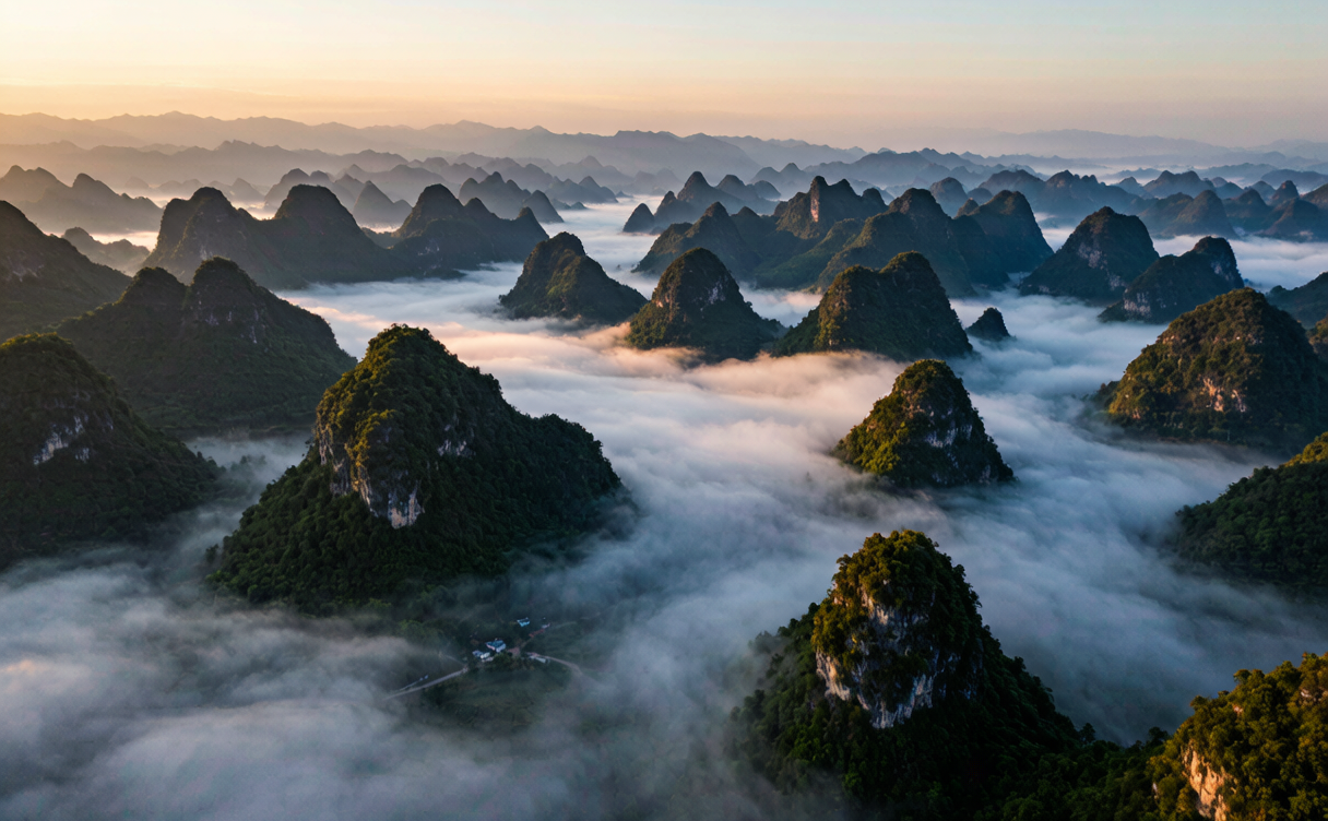
Guilin gets the karst tourists. Two hundred and fifty kilometres northwest, in the corner of Guizhou where three provinces meet, the same limestone does something stranger: instead of standing over a river, several thousand cone-shaped hills rise straight out of flat farmland, and villages and rice paddies fill the gaps between them. Locals farm the floor of the basin; the peaks are simply there, in every direction, all the way to the horizon. This Wanfenglin guide covers when the fields look their best, which viewpoints are worth the climb, how to cycle the valley, and how to reach a place that still sees very few foreign visitors.
Why Visit Wanfenglin
The name means Ten Thousand Peak Forest, and for once the Chinese hyperbole undersells it. The formation covers roughly 2,000 square kilometres of Xingyi’s southern outskirts, with an estimated 20,000 karst cones. The seventeenth-century geographer Xu Xiake travelled here and wrote that nothing else in the empire compared, which is the quote every local guide will hand you.
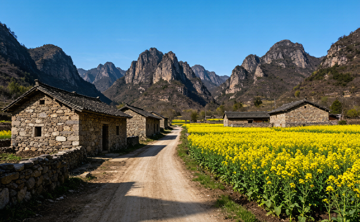
What makes it different from Guilin or Yangshuo is the farmland. There is no river cruise, no bamboo raft, no bar street. Instead there are eight villages strung along a valley road, terraced rice and maize plots worked by Buyi families, and the peaks standing in among them like a crowd. In good light the effect is genuinely disorienting: the horizon is a saw-blade in every direction.
If you are planning a Guizhou route, Wanfenglin sits on the doorstep of Xingyi, the nearest city, and connects west from Guiyang in under two hours by train.
Wanfenglin Best Time to Visit
The landscape changes so much by season that the Wanfenglin best time to visit depends entirely on what you want in the frame.
Late April to early June — flooded paddies. The fields are under water and mirror the peaks. This is the photographer’s season, alongside the yellow rapeseed that flowers in the lower basin in March and April. Temperatures 18–28°C, frequent afternoon showers.
Late September to October — golden harvest. Rice turns and the valley goes gold before cutting. Clear, stable weather at 15–26°C, the best all-round window, and the one most visitors should pick.
July and August. Deep green, tall rice, dramatic cloud. Hot at 26–33°C and the wettest months, but morning mist between the cones is at its most reliable.
November to February. Cool and dry at 5–16°C, fields bare and brown, very quiet. Sightlines are longest in winter haze-free spells, so it suits walkers more than photographers.
Skip the first weeks of May and October if you can, when domestic holiday traffic clogs the single valley road.
Xingyi Peak Forest Viewpoint Options
There are three ways to see the formation, and they are not interchangeable.
The Wanfenglin observation decks. A road climbs the eastern ridge to a series of platforms, the main Xingyi peak forest viewpoint, where you look down the length of the valley with peaks receding in rows. Shuttle buses run up from the ticket gate. This is the postcard view and the one worth timing for sunrise.
The valley floor. The road through Xiajiao, Shuanglong and the other villages puts you among the cones rather than above them. Better for a sense of scale and for seeing farm life; less good for photographs.
Wanfenglin’s twin peaks and the caves. Several smaller sights sit off the main road, including a cave system and the Nahui village viewpoint on the western side, which catches evening light when the main decks are already in shadow.
Wanfenglin Cycling Route
The valley is flat, the road is paved, and the traffic is light outside holidays, which makes this one of the better rides in southwest China. A Wanfenglin cycling route that most people can manage:
Start at the north gate near Xiajiao, ride south through the villages to Shuanglong, continue to the Eight Trigrams fields where the plots are laid out in a radial pattern around a low mound, and turn back at Nahui. That is roughly 22 kilometres round trip with almost no climbing, and it takes three to four hours with photo stops.
Bikes rent for ¥40–60 a day near the north gate, and electric scooters for ¥80–120 if you would rather not pedal in the heat. Electric shuttle buggies run the same road for ¥20–40 a leg if you want to skip sections. Cyclists should carry water; there are village shops but they are spread out.
Wanfenglin Photography Spots
The Wanfenglin photography spots that repay an early alarm:
- Main observation deck at sunrise. Mist sits in the valley floor and burns off between 07:00 and 08:30. The peaks separate into layers. This is the shot.
- Eight Trigrams fields (八卦田), mid-morning. Concentric plots around a central cone, best from the small hill on the east side of the road.
- Nahui viewpoint at sunset. West-facing, so the cones rim-light while the eastern decks go flat.
- Flooded paddies after rain, late April to May. Reflections double the peaks. Get low and shoot into the light.
Drone flying is common here but restricted near the airport on Xingyi’s north side; check locally before launching. For a wider view of shooting karst and terrace country, our China photography tour guide covers light, seasons and permissions across the main regions.
How to Get to Wanfenglin
The practical answer to how to get to Wanfenglin is: reach Xingyi, then drive 20 to 40 minutes south.
| From | Mode | Duration | Approx. cost |
|—|—|—|—|
| Guiyang → Xingyi | High-speed rail | 1 hr 40 min – 2 hr | ¥110–170 (US$15–24) |
| Kunming → Xingyi | High-speed rail | 2 hr – 2 hr 30 min | ¥130–190 (US$18–27) |
| Guangzhou → Xingyi | High-speed rail | 4 hr 30 min – 5 hr 30 min | ¥300–420 (US$42–59) |
| Xingyi Station → Wanfenglin | Taxi or ride-hail | 30–40 min | ¥60–100 (US$8–14) |
| Xingyi city → Wanfenglin | Local bus | around 1 hr | ¥8–12 (US$1–2) |
Xingyi also has a small airport with flights from Guiyang, Kunming, Chongqing and Guangzhou, 25 minutes from the valley. A car with driver for a full day costs ¥400–600 and is the easiest way to combine the observation decks with the valley villages.
Where to Stay
Valley guesthouses — ¥150–350 (US$21–49). Buyi family homestays and small boutique inns in Xiajiao and Shuanglong, some with terraces facing the peaks. This is where you want to be for sunrise. Confirm foreign-passport registration when booking; several of the smallest cannot.
Wanfenglin boutique hotels — ¥400–800 (US$56–112). A handful of design-led properties have opened along the valley in recent years, with peak-facing rooms and decent kitchens.
Xingyi city — ¥140–320 (US$20–45). Standard chain hotels, reliable registration, better restaurant choice, but a 40-minute drive from the light you came for.
Two nights in the valley beats three in the city. The whole point is being there at dawn.
Tickets and Opening Hours
Entry to the Wanfenglin scenic area runs roughly ¥60–80 (US$8–11), with the internal shuttle to the observation decks a further ¥30–40. Gates generally open 07:30 and stop selling tickets around 17:30 from April to October, with slightly shorter winter hours. The valley road itself is a public road, so cycling the villages does not always require the scenic ticket, but the decks and marked sights do. Passports are checked at the window. Regional tourism information, including seasonal notices, is published by the Guizhou provincial government portal.
Practical Tips
- Passport for rail tickets, gates and hotel registration.
- Alipay and WeChat Pay are universal; keep ¥200–300 cash for village shops and homestays.
- Sun protection. The valley floor has no shade at midday.
- Rain. Guizhou is wet. A packable shell and a dry bag for cameras earn their space.
- Language. Effectively no English. Save village names in characters.
- Food. Buyi cooking: sour soup fish, glutinous rice cakes, cured pork and chilli. A meal for two runs ¥80–150.
- Altitude. Around 1,000 to 1,200 metres, so nights are cooler than you expect even in summer.
FAQ
Is Wanfenglin worth visiting?
Yes, if you want karst scenery without the tourist machinery around it. The density of peaks is greater than at Yangshuo and the farming villages are still working ones. It is a two-day stop with a strong photographic payoff.
How does it compare to the Longji rice terraces?
Different landform. The Longji rice terraces are carved hillsides you climb; Wanfenglin is a flat basin you look across, with peaks instead of slopes. Many travellers do both on a southwest loop.
How many days do I need?
Two nights. One dawn at the observation deck, one day cycling the valley, and a spare afternoon for the caves or Nahui. A single day trip from Xingyi only really gets you the decks.
What else is nearby?
The Maling River Gorge is 15 minutes from Xingyi, and the karst lakes and bridges at Libo Xiaoqikong are a few hours east. Travellers who like quieter routes should also see our off-the-beaten-path China guide.
Written by Karl, China Travel Places — updated August 2026.