

Crossing the Taklimakan by road, I watched the asphalt ribbon disappear into a wall of dunes on both horizons and understood why old Silk Road travelers called it the “Sea of Death.” The Taklimakan Desert in Xinjiang, China is the largest shifting-sand desert in the country and the second-largest in the world, a forbidding expanse that once swallowed whole caravans. Today a ribbon of highways lets cautious travelers skim its edge — an adventure that rewards respect, preparation, and the right season, and that few foreign visitors attempt on their own.
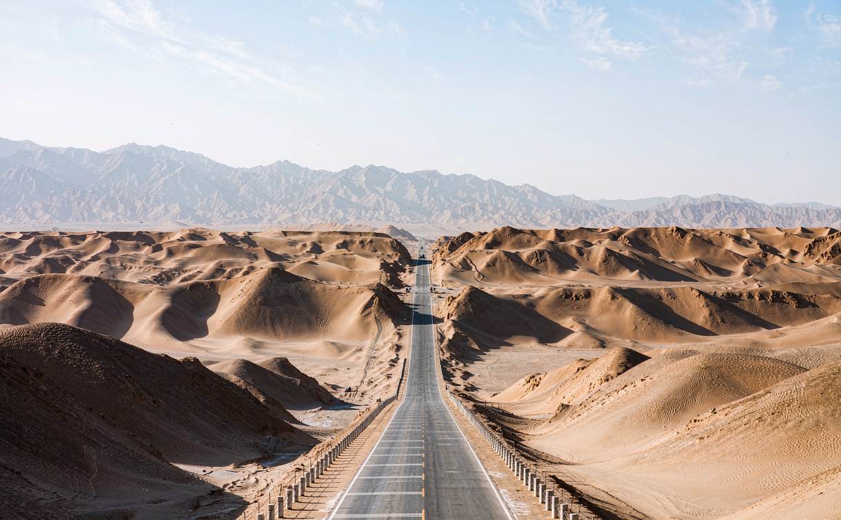
The Sea of Death, Tamed by Highways
The name Taklimakan (塔克拉玛干) is often glossed as “you can get in but you can’t get out,” a nod to its deadly reputation. Covering about 337,000 square kilometers — roughly the size of Germany — it sits in the Tarim Basin, ringed by the Kunlun, Pamir, and Tianshan mountains. Beneath the dunes lie the Tarim River and one of China’s most important oil and gas fields, which is exactly why two remarkable roads now cross it and why the crossings are maintained against the constant drift of sand.
The best known is the Tarim Desert Highway (also called the Taklamakan Desert Highway), a roughly 522-kilometer (324-mile) paved road from Lunnan in the north to Minfeng in the south. It was the first highway built straight across a shifting-sand desert, completed in 1995, and it is lined with a remarkable windbreak of vegetation-protected squares planted to hold back the sand. A second crossing, the Heshuo-to-Ruoqiang highway, opened more recently and links the desert’s eastern side. Driving either is an unforgettable experience: for hours the only features are dunes, sky, and the occasional maintenance station with its greenhouses and pumped water.
I crossed the Tarim Highway on a clear October morning and saw perhaps three other vehicles in four hours. The silence at the roadside pull-offs is absolute, broken only by wind moving the crest lines. This is not a place to wander off the pavement — the sand is soft, the distances are enormous, and help is far away, so the highway itself is the attraction and the discipline. For the regional framing, our this Xinjiang, China travel guide explains how the desert splits the region into northern and southern routes that once took caravans weeks to round.
What to Do and How to Cross
Most visitors experience the Taklimakan from the safety of a car rather than on foot. The signature activity is simply driving the highway and stopping at the desert lookout platforms, where you can climb a couple of guarded dune faces for photos and read the plaques about the road’s construction. Adventure operators in Korla or Aksu sometimes offer guided 4×4 dune excursions to the roadside fringe, typically priced from 600–1,200 RMB per vehicle for a half day, always with recovery gear and a local guide who knows where the sand is firm. Camel treks into the deeper desert are possible only on organized, permitted expeditions and are not something to attempt independently.
The desert also frames oasis towns worth visiting on its rim: Kashgar to the west, Hotan to the southwest, Kuqa and Aksu to the north. I paired a highway crossing with a few days in Hotan’s jade markets and Kuqa’s canyon country, which gave the dunes context as both barrier and trade route rather than just a blank on the map. Our the China Silk Road itinerary shows how caravans skirted these edges for centuries, and the Kashgar old town guide covers the western gateway most travelers use before or after the crossing.
Thinking of driving the Sea of Death? Get our fuel-stop list, seasonal warnings, and the oasis towns to use as safe bases on each side of the crossing so you never run the tank or the clock too low.
Tickets, Logistics, and How to Get There
There is no gate or ticket for the desert itself — the experience is the highway and the rim oases, which keeps costs low and planning simple. The Tarim Desert Highway is a public road with free access, though you will pass occasional checkpoints requiring ID, so carry your passport and any permits for restricted adjacent zones. The nearest major airports are in Korla (north) and Hotan (south), with Urumqi about a full day’s drive away; domestic flights from Urumqi to Korla or Hotan cost roughly 400–900 RMB one way depending on season. Renting a car with a driver is the safest way to cross, and a through-drive from Korla to Hotan takes about 10–12 hours including stops, so most travelers break it with an overnight in a rim town rather than attempting it in one push.
Self-driving is permitted but demands preparation: carry extra water (at least 4 liters per person), a full spare tire, offline maps, and fuel up at every station because they are spaced 100–200 kilometers apart with nothing between them. If you are building this into a regional route, the a 7-day Xinjiang, China itinerary can slot the crossing between Kashgar and Turpan, and our things to do in Urumqi, Xinjiang, China page covers the usual starting point for flights and the train into the north of the basin.
Worried about breaking down mid-desert? Our pre-drive checklist covers spare tires, water math, and the exact fuel stations to fill at, so the crossing stays an adventure rather than an ordeal with heat and distance working against you.
Best Time and Where to Stay
The window is narrow. October and April are the only truly comfortable months, with daytime temperatures around 15–28°C (59–82°F) and calm enough wind for photos at the pull-offs. Summer is dangerous — surface temperatures can exceed 70°C (158°F) and the car’s air conditioning is essential, while winter brings freezing nights and occasional snow on the northern rim. I strongly advise against any off-road desert travel between June and August, when heat and the rarity of traffic turn a breakdown from inconvenient to serious.
Lodging means the rim oases: Korla and Aksu in the north, Hotan and Minfeng in the south, where mid-range hotels run 250–500 RMB per night and offer the air conditioning and water you will want after a day on the sand. There is no accommodation in the desert interior, so plan your overnight around the highway ends. For the Silk Road framing of why this desert mattered, our the China Silk Road itinerary shows the longer loops that once took months and explains why a straight road across it is a modern marvel.
For authoritative background, the Wikipedia page on the Taklimakan Desert documents its size, climate, and the highways that now cross it.
Visiting tips & costs for the Taklimakan crossing
Crossing the Taklimakan Desert in Xinjiang, China is less about tickets and more about preparation, and a few numbers keep the adventure safe. There is no gate or fee for the desert itself — the Tarim Desert Highway is a public road with free access — but you will pass checkpoints requiring your passport, so carry it and any permits for adjacent restricted zones. The smartest entry points are Korla or Aksu in the north and Hotan in the south; domestic flights from Urumqi to either run roughly 400–900 RMB one way by season, and a Korla-to-Hotan through-drive takes about 10–12 hours with stops, so most travelers break it with an overnight in a rim town rather than pushing straight through. Renting a car with a driver is the safest approach.
What to carry is non-negotiable. Pack at least 4 liters of water per person, a full spare tire, offline maps, and fuel up at every station, because they sit 100–200 kilometers apart with nothing between them. Self-driving is permitted but demands respect for the distances; the sand is soft, help is far, and a breakdown between June and August turns serious fast because surface temperatures can exceed 70°C. We recommend the shoulder months of April and October, when daytime temperatures sit around 15–28°C and the pull-off platforms are calm enough for photos. Budget for rim-town lodging at 250–500 RMB per night in Korla, Aksu, Hotan, or Minfeng, where the air conditioning and water matter after a day on the sand. Pair the crossing with Hotan’s jade markets or Kuqa’s canyon country so the dunes read as both barrier and trade route. Our Silk Road itinerary shows the longer loops that once took caravans months, and why a straight road across this sea of dunes remains a modern marvel worth the respect it demands.
Cross the Sea of Death the smart way — download our checkpoint checklist, fuel-planning map, and the best rim-town hotels for a safe two-day crossing that still feels like the edge of the world.
The Taklimakan is not a place to conquer; it is a place to witness. From the safety of the highway, you can feel the scale that once terrified the world’s greatest travelers — and come home with a story very few visitors to Xinjiang, China can tell.