

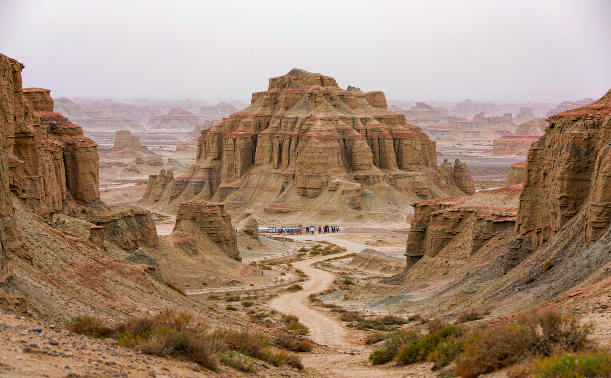
In the far west of Tibet, China, near the border with India and Nepal, the Zanda Earth Forest rises from the valley floor like a petrified city. These towering columns of reddish clay and gravel were carved over millions of years by wind and the seasonal runoff of the Langchen Tsangpo, the upper Sutlej River. The result is a maze of slender spires, eroded arches, and shadowed gullies that glow orange at dawn and deepen to rust at dusk. For travelers on an Ngari Tibet tour, the earth forest is the surreal overture to the sacred sites of the Guge Kingdom that sit hidden within it.
The long road to Zanda in Ngari
Zanda sits in Ngari Prefecture, the most remote corner of Tibet, China, and reaching it is a journey in itself. Most visitors fly from Lhasa to Ngari’s Ali Kunsha Airport, then drive two to three days west through Shigatse and the high passes of the western plateau. The Lhasa Tibet travel guide explains the permit process and the acclimatization steps you should take before flying into such altitude, because Zanda itself stands above 3,700 meters and the surrounding drives cross passes well over 5,000 meters. Foreign travelers must travel with a licensed Tibet guide and a grouped permit, so plan this leg through a registered operator.
A Zanda to Lhasa return by road is roughly 1,500 kilometers and takes at least five driving days each way, which is why most people fly one direction. The China road trip guide notes why self-driving in Ngari is rare for visitors and why hiring a 4×4 with a driver is the standard, safer choice on these rough, high-altitude tracks.
Things to do at Zanda Earth Forest
The earth forest is best explored slowly, either from the viewing platforms near the road or on foot along the gullies below. A Zanda canyon photography session at first light is the main draw: the low sun rakes across the columns and throws long shadows that make the formations look like a ruined metropolis. Bring a wide lens for the skyline of spires and a telephoto to isolate individual towers. Drone use is restricted near the border, so check with your guide before flying.
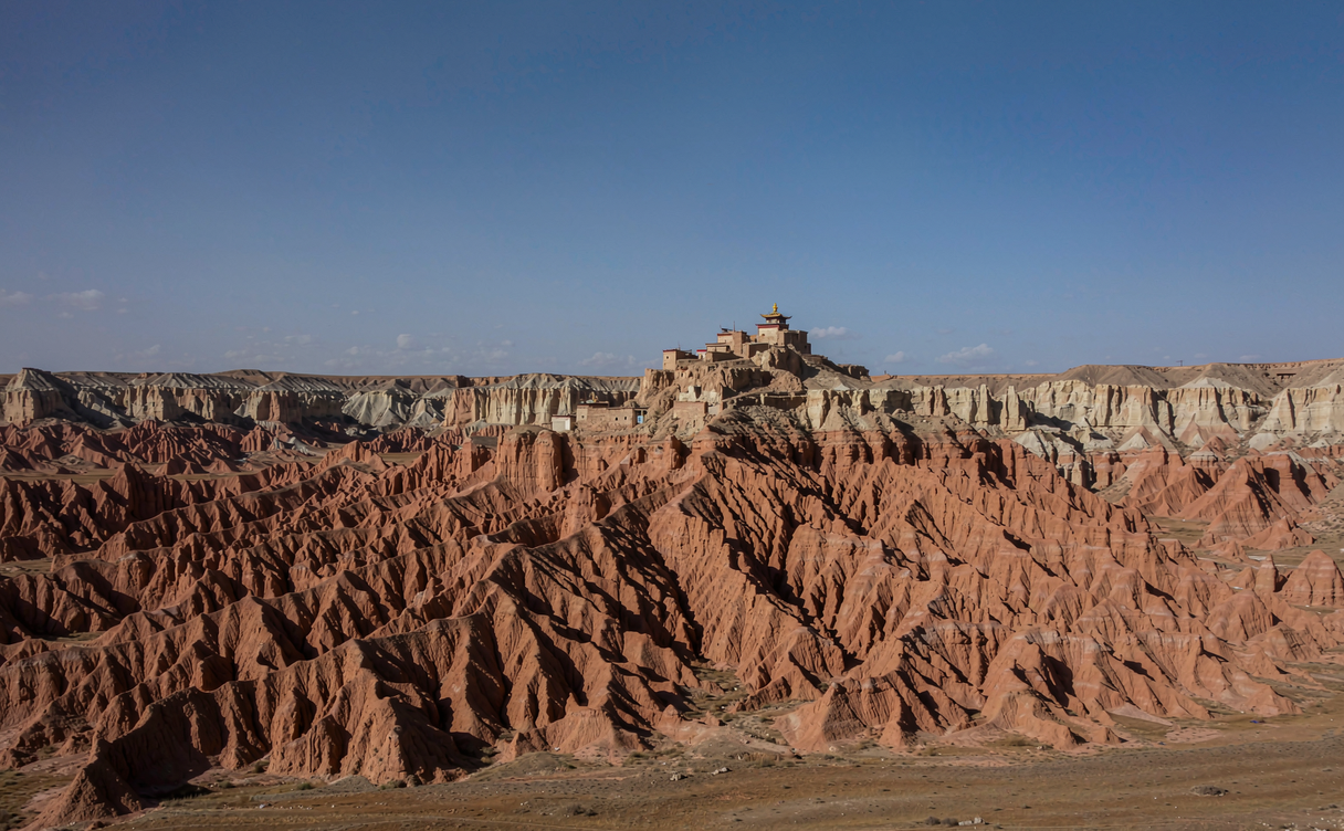
Just beyond the formations lie the ruins of the Guge Kingdom, a 10th-century Tibetan dynasty whose monasteries and murals cling to a cliff within the earth forest. Combining the two in one visit is natural, since the clay canyons protected the citadel for centuries. The nearby village of Zanda has basic guesthouses and a small museum displaying artifacts recovered from the ruins. For a broader perspective on Tibet’s protected landscapes, the China national parks guide compares Ngari’s scenery with other designated reserves across the country.
Best time to visit Zanda
The best time to visit Zanda is June through September, the short warm season when the roads are passable and the nights, while cold, stay above the worst winter extremes. May and October can work but bring sudden snow on the high passes. From November to April, heavy snow routinely closes the routes, and most guesthouses shut. Even in summer, nights drop near freezing, so pack a real sleeping bag rated for zero and layers you can add through the day.
Altitude is the constant factor. Move slowly, drink plenty of water, and give yourself a few days at lower Tibetan towns before pushing west. The thin, dry air also makes the light exceptionally clear, which is part of why the Zanda clay forest Tibet photographs so well.
Pairing Zanda with wider Tibet routes
Most Ngari travelers build a loop that also reaches the south. The Shigatse travel guide covers the city that anchors the southern approach and the monasteries worth seeing on the way west. Further into the Himalaya, the Everest Base Camp Tibet guide details the permit and vehicle steps for standing beneath the world’s highest peak, a natural companion to the empty west. For lakes rather than canyons, the Tibet Basum Tso guide describes a forested highland lake in the east that feels like another world from the arid Ngari plateau.
The Guge Kingdom ruins inside the cliffs
The earth forest is more than scenery; it hides the remains of the Guge Kingdom, a Tibetan dynasty that ruled western Tibet from the 10th century after the collapse of the earlier empire. Its capital was built into a pinnacle of clay cliff, with palaces at the top, monasteries carved mid-slope, and dwellings and stables below. Today you can walk the narrow paths up to the assembly hall, where murals in vivid mineral pigments still cover the walls, and peer into the caves that once held monks and stores.
The site is a powerful counterpoint to the empty canyons. The Guge people abandoned the kingdom in the seventeenth century after a siege, and the silence of the ruins against the eroded towers makes the history feel close. A local guide brings the layout to life, pointing out the defensive channels and the secret escape route. Allow half a day so the altitude and the climbing do not rush you, and carry water for the ascent.
Photography gear and on-site safety
Shooting the earth forest well means planning around the light. The spires face east, so sunrise lights their faces while sunset leaves them in long shadow; most photographers favor the morning. A sturdy tripod helps in the wind that funnels through the gullies, and a dust cloth protects your lens from the fine clay that the breeze lifts. Wide lenses capture the skyline of towers; a mid-zoom isolates single arches.
Safety is mostly about altitude and road conditions. Walk the marked paths and avoid the crumbling edges of the gullies, which give way without warning. Stay with your group and guide, since mobile coverage is patchy and the border region is sensitive. Tell your operator your plans each morning, carry extra water and a warm layer even in summer, and turn back early if weather closes the passes. The reward is a set of images found almost nowhere else in Tibet, China.
Where to eat and stay
Zanda village has a few simple restaurants serving Tibetan noodles, yak meat, and momos, plus the staples of rice and vegetables trucked in from farther east. Do not expect variety or Western food; this is the deep frontier. Guesthouses are basic but heated, and it is worth booking through your tour operator since independent walk-in options are limited and seasonal.
Carry cash, as card and mobile payments are unreliable this far west. A good outside reference is the Wikipedia entry on Ngari Prefecture, which gives useful geography and history of the region that surrounds the earth forest, helping you place the formations within the wider Tibetan plateau.
A practical sample plan
Day one: fly Lhasa to Ali, overnight in the prefecture town to rest. Day two: drive to Zanda, arrive by afternoon, shoot the earth forest at sunset. Day three: sunrise photography, visit the Guge ruins, and return west. This leaves buffer for weather and the slow pace altitude demands.
Zanda rewards patience and preparation. It is not an easy destination, but the sight of those silent clay towers under a vast Ngari sky is one of the most otherworldly scenes in all of Tibet, China, and a fitting centerpiece for any far-west pilgrimage loop.