

I still remember the moment the clouds lifted near Nyingchi and I caught my first glimpse of the Yarlung Tsangpo Grand Canyon. Standing at a roadside viewpoint, I watched the Yarlung Zangbo River carve a near-vertical scar through the Himalayan foothills, the water a thin silver thread thousands of meters below. It was the kind of sight that makes you stop talking.
Most foreign travelers have heard of the Grand Canyon in Arizona, but few realize that the Yarlung Tsangpo Grand Canyon (also spelled Yarlung Zangbo and often called the Tsangpo Canyon) is, by some measures, the deepest gorge on Earth. Reaching it takes effort, permits, and a tolerance for altitude, but it rewarded me with scenery I have not seen anywhere else in China.
In this guide I’ll walk you through exactly how I got there from Nyingchi, what you can actually see and do, the sacred Namjagbarwa Peak that guards the gorge, practical tips, and the best window of the year to visit.
Getting There from Nyingchi
Nyingchi (Lin zhi) is your launch pad. It has an airport with flights from Chengdu and Lhasa, and it sits at a friendlier altitude than Lhasa, around 3,000 meters, which helped me acclimatize before going deeper.
The canyon’s main gateway is the town of Pai (Paizhen), about 70 kilometers from Nyingchi city. I hired a car with a driver for the day, which cost roughly 600–800 yuan and took around two hours each way on a paved but winding mountain road. Public buses run from Nyingchi bus station to Pai, but they are infrequent and you lose the freedom to stop at viewpoints.
A few things to plan before you leave:
- You need a Tibet Travel Permit, arranged through a registered tour operator before you fly into the region.
- Within the canyon area, certain viewing platforms and the Sejila Mountain pass are open to independent visitors, but the inner gorge trails require a local guide.
- Carry your passport and permit at all times. Checkpoints are real and they do stop cars.
I found the drive itself worth the price. The road follows the river, swings past terraced barley fields, and climbs through forests of pine and rhododendron before opening onto the first big overlook.
What to See
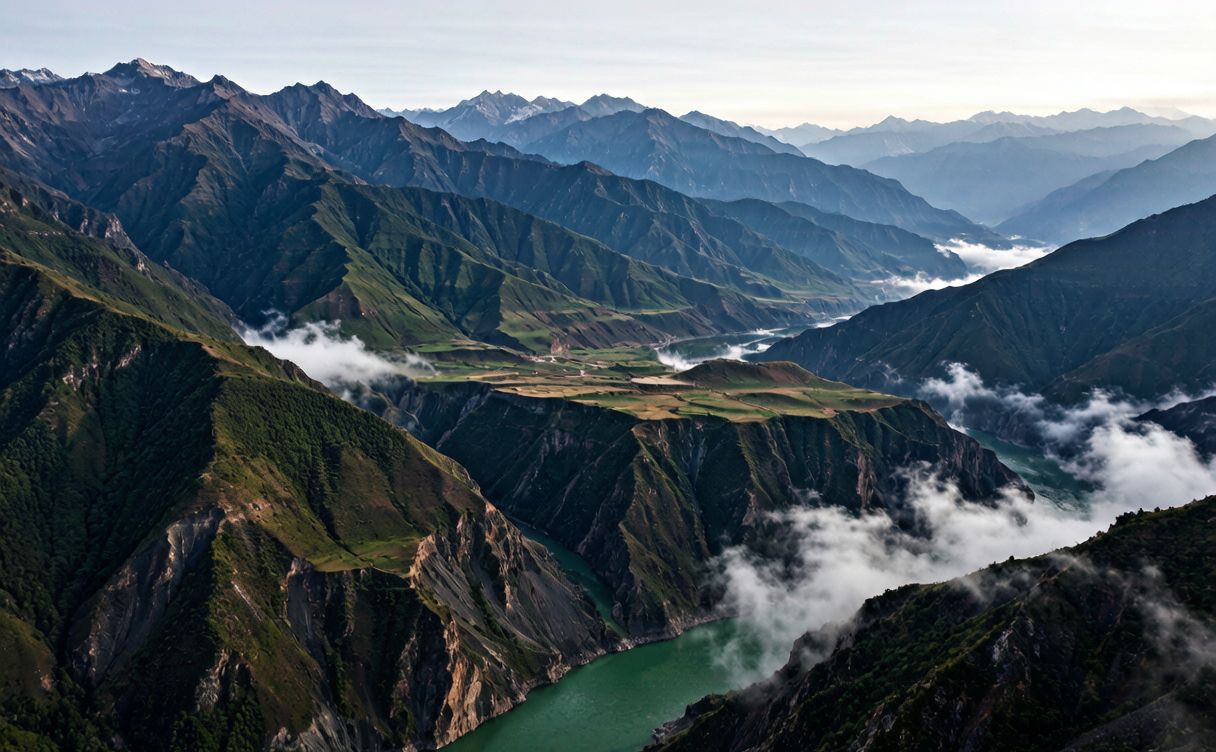
The canyon stretches for about 500 kilometers, but the dramatic, tourist-accessible section is the great bend where the river hooks sharply around Namjagbarwa and plunges through a gorge over 5,000 meters deep in places. Here is what I spent my time on.
The Great Bend (Horse’s Mouth). This is the headline sight. The Yarlung Tsangpo makes an almost 180-degree U-turn around the mountain. From the Sichuan-Tibet Highway viewpoints you can see the layered ridges stacked into the distance. On a clear morning the light rakes across the walls and the scale finally sinks in.
Tibetan villages inside the gorge. I stayed a night in a small village along the river, where stone houses are stacked on the slopes and prayer flags snap in the wind. Locals offered butter tea and tsampa, and a family invited me to watch the evening puja at a roadside shrine. This is the human side of the canyon that photos never capture.
Hot springs. Near Pai there are basic outdoor hot springs fed by the same geothermal system that powers the region’s volcanoes. Soaking in steaming water while a cold mist drifts off the river was one of my favorite quiet moments.
Waterfalls and side gorges. The seasonal Namcha Barwa waterfall and smaller side creeks are best after rain. Bring shoes with grip; the trails are slick.
The whole area is raw and lightly developed. That is the appeal. You are not in a theme park; you are in a working Himalayan landscape where the road, the river, and the villages share the same narrow ribbon of valley floor.
Namjagbarwa Peak
If the canyon is the stage, Namjagbarwa is the star. At 7,782 meters, Namjagbarwa is the highest peak in the eastern Himalayas and one of the most beautiful mountains I have ever seen. Tibetan pilgrims call it a sacred peak, and local guides told me its full name means “spear piercing the sky.”
The problem is clouds. Namjagbarwa is notorious for hiding behind a veil of mist, sometimes for weeks at a time. I got lucky on my second morning: I woke at 5 a.m., drove to the Sejila Mountain pass viewpoint, and at first light the entire pyramid face lit up gold for maybe ten minutes before the cloud rolled back in. Those ten minutes were worth the whole trip.
Practical notes from my own attempts:
- The best viewing spots are the Sejila pass (4,720 meters) and the riverside platforms near Yarlung village.
- Go at dawn. After 9 a.m. the rising air usually clouds the summit.
- Bring a warm layer even in summer. At the pass it was near freezing before sunrise.
- Manage expectations. If the weather does not cooperate, enjoy the gorge itself and try again the next morning.
Seeing Namjagbarwa clear is a lottery, but it is a generous one if you give it two or three mornings.
Tips
I learned a few things the hard way, so here is the short version.
- Acclimatize first. Spend at least a day or two in Nyingchi or Lhasa before descending into the gorge. The viewpoints sit between 2,900 and 4,700 meters.
- Dress in layers. Sun, wind, and sudden rain all happen in one afternoon. I carried a rain shell, a fleece, and sunglasses.
- Fuel up on food and cash. Pai has a couple of simple restaurants and no reliable ATMs. I took yuan in cash and snacks from Nyingchi.
- Hire a local guide for the inner trails. The gorge is easy to get lost in, and a guide also opens doors to village homestays.
- Respect the culture. Ask before photographing people or shrines. Walk clockwise around Mani stone piles and prayer wheels.
- Mind the altitude on hikes. Move slowly, drink water, and turn back if you feel dizzy or nauseous.
I also kept my camera battery warm in an inside pocket; cold drains it fast at altitude.
Best Time
The canyon has a short, sweet season. I went in late April and found it excellent, but here is the full picture.
- March to May (spring). My pick. Clearer air, blooming rhododendrons, and decent odds of seeing Namjagbarwa between weather systems.
- September to November (autumn). Also great. Stable, dry days and the clearest mountain views of the year. This is peak season for a reason.
- June to August (summer). Lush and green, but the monsoon brings heavy rain, leeches on lower trails, and more cloud hiding the peak. Roads can wash out.
- December to February (winter). Cold and some passes close with snow, but the air is crystal clear and crowds vanish. Only for well-prepared travelers.
If you want the best balance of weather, flowers, and lighter crowds, aim for April or early May, or October.
Good to Know
The Yarlung Tsangpo Grand Canyon is part of a protected nature reserve managed under regional tourism authorities. Before you travel, check the latest entry rules and permit requirements with the official Tibet tourism board at Tibet Tourism, and confirm whether the inner gorge is open, since access can change with the season and weather.
Ready to build your Tibet trip? Start with our complete Lhasa Tibet travel guide for permits, the Potala Palace, and how to acclimatize before heading east.
Planning the rest of your Tibet route? Our [Lhasa Tibet travel guide](https://www.chinatravelplaces.com/lhasa-tibet-travel-guide/) covers permits, the Potala Palace, and where to stay in the capital before you head toward Nyingchi and the gorge.
If you want to pair the canyon with higher-altitude highlights, our Everest Base Camp Tibet guide explains the drive toward the world’s highest mountain, and the Tibet Namtso Lake guide shows you the sacred alpine lake north of Lhasa.
Combining the canyon with a sacred lake? Read the [Tibet Namtso Lake guide](https://www.chinatravelplaces.com/tibet-namtso-lake-guide/) for how to visit the sky-blue highland lake on your way in or out of Lhasa.
For more dramatic mountain scenery across western China, I also recommend the Yunnan Meili Snow Mountain guide and the Xinjiang Nalati Grassland guide, both of which pair beautifully with a Tibet itinerary.
Want snow mountains beyond Tibet, China? Our [Yunnan Meili Snow Mountain guide](https://www.chinatravelplaces.com/yunnan-meili-snow-mountain/) and [Xinjiang Nalati Grassland guide](https://www.chinatravelplaces.com/xinjiang-nalati-grassland/) map out two more unforgettable western-China landscapes.
The Yarlung Tsangpo Grand Canyon, Tibet, China is not an easy destination, but that is exactly why it stays with you. Go with patience, a warm jacket, and a few mornings to spare for Namjagbarwa, and you will leave with a gorge burned into memory.